Client: Ministry of Energy/ Regional water Company of Tehran
Project's Geographical Location: The Margin of Karaj river in the scope of Karaj city/ Tehran Province
Project Description:
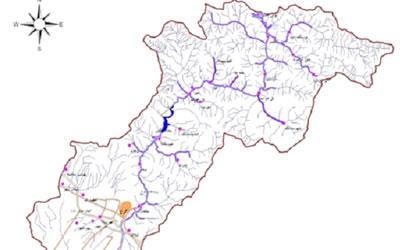
Karaj River is the most water-filled river basin of central Plateau located in the northwest of the basin and its origin is located near the originated of Haraz, Challus and Jajrood rivers.Its primary tributaries are the names of the provinces and varvshvn of the Middle Mountains and the mountains of the Palun (located in north Tehran and northeast of Karaj) fall.
The river is in a high-maze and canyon-Deep hospital Pass through the Gachsar region and then join small branches such as the old Ten, Gshtarood, Shahrestanak, the Leanyz and the Kiasar., Then the river enters the lake of Karaj Dam and after leaving the dam and receiving other branches such as Arhold, Tojon and Frankincense are redirected by crossing the city of Karaj and in southeast direction.
Above studies By examining more than 18 intervals during the Karaj River, approximately 174 kilometers in order to prevent damages during the river outbreak with an emphasis on preventing the pollution of Karaj River and improving the water quality of this river by this consultant is on going.